On the west bank of the Tenn. River, directly
across the river from Johnsonville, a community formed and
thrived with the railroad. First settled in 1868 and
known as Bartlett's Switch, the name Eva was adopted in 1871,
named for the first Postmaster's daughter's best friend.
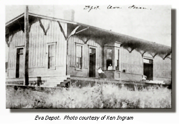
The town ultimately boasted a tomato cannery, blacksmith shops,
several stores, saloons, and two hotels, as well as a railway
depot.
As the railroads continued to expand, merge, and absorb,
the Nashville and Northwestern and Nashville and Chattanooga
themselves merged together under lease in 1870, and then formally
became the Nashville, Chattanooga and St. Louis Railway in
1873. The L&N, a direct competitor with the ambitious
NC&StL in this region, bought a controlling interest in
NC&StL stock in 1880, thus becoming the majority owners
of the line. (To prevent the "&StL" part
of the name; the NC&StL never directly reached St. Louis.
Hickman and Paducah, Kentucky, were as far northwest as NC&StL
trackage ever went.). The L&N allowed the NC&StL to
operate as a separate autonomous entity for the next 77 years.
In 1957, the L&N once and for all absorbed the profitable,
revenue-generating NC&StL, arguably initiating the "merger
mania" among railroads still with us today.
Time once was in this country when the traveling populace
and the goods they consumed moved by rail. And as the railroad
flourished, so did the small community on the Tennessee River
known as Eva.
|
|
Bottom land, especially on the west side of the river,
was prone to significant spring flooding. In the early
1930's, with the country in the throes of the Great Depression,
the Tennessee Valley Authority (TVA) was created with the
purpose of controlling this flooding, creating cheap electrical
power, as well as creating work, via a chain of dams.
Gilbertsville Dam, near Gilbertsville, Kentucky, one of the
last TVA dams in the project, would raise the overall level
of the river and create a pool to be known as Kentucky Lake.
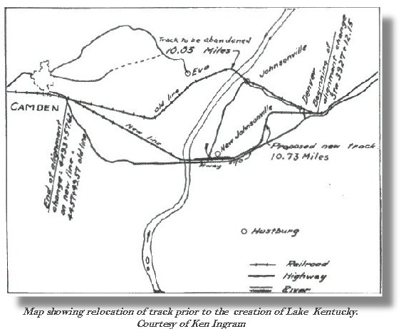
It was clear the NC&StL railroad bed on the west bank
of the river would be flooded, and the bridge and associated
trestle would have to be relocated. This would be an
expense that, in light of planned improvements to the railroad
necessitated by years of overall decline during the depression
and the subsequent demands of World War II, the line could
ill afford to bear. |
|
| |
|
|
Contract was entered into with the TVA in 1943, during World
War II, and a draw bridge, previously utilized further north
on the Tenn. River by the Illinois Central Railroad at Gilbertsville,
was relocated to near Camden, Tenn., adjacent to U.S. highway
70, some six miles south (upstream) from Eva. A total
of 10.05 miles of railroad, road bed, trestles, and bridge
were abandoned, the job being completed in 1945. With
the majority of what was Eva and the rich river bottom land
submerged in the newly-created Kentucky Lake combined with
the subsequent loss of the railroad, the once-thriving community
all but disappeared, while Johnsonville (now New Johnsonville),
across the river, was relocated to higher ground three miles
south. A look at NC&StL timetable and annual report
route maps show Eva as late as 1944. Route maps from 1945
bear no trace. The entire cost of this project, $2.5 million,
was borne by the TVA.
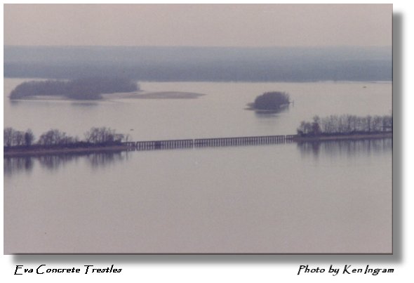
Above photo taken October 2002 from atop Pilot Knob on the
Eva side of Kentucky Lake/Tennessee River looking down on
an old concrete railroad trestle left in place when the NC&StL
abandoned 10 miles of main-line trackage in 1945. The two
connecting "islands" were once rail road bed (levees
to avoid the annual spring flooding - much like the permanent
lake in the photo). This has got to be a unique trestle, in
terms of its construction. I don't believe there was ever
any sort of superstructure, just open cross ties on concrete
similar to the FEC Railway's Key West Extension viaducts.
I'm no expert, but I've never seen anything quite like it,
and it is still there - rare and tangible (by boat) evidence
of the NC&StL or possibly even Nashville and Northwestern
that was never merged into the L&N. -- Ken Ingram
|
|
|
1912 Statistics: Population 75 (as of 1910), Elevation 362, Benton
County, Tennessee
|
|